

Hello guys,
This time not a Soldbuch but a US Army minefield map I picked up locally.
The map contains the details about 75 antitank mines and booby traps that have been placed by G Company of the 18th Infantry Regiment (1st US Inf Div) on December 27 1944.
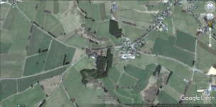
Because of the coordinates and map details it was relatively simple to find the exact place where this sketch was made, it is the hamlet Bütgenbacher Hütte.
Here the German advance was halted a week before, the tanks of the 12th SS Pz Div Hj were halted on December 19 1944 in the nearby hamlet Dom-Bütgenbach, since then the frontline in this sector was stabilized, the heights south of Bütgenbach were occupied by members of the 5th & 8th Fallschirmjäger Regiments.
Cheers,
Peter
This time not a Soldbuch but a US Army minefield map I picked up locally.
The map contains the details about 75 antitank mines and booby traps that have been placed by G Company of the 18th Infantry Regiment (1st US Inf Div) on December 27 1944.
Because of the coordinates and map details it was relatively simple to find the exact place where this sketch was made, it is the hamlet Bütgenbacher Hütte.
Here the German advance was halted a week before, the tanks of the 12th SS Pz Div Hj were halted on December 19 1944 in the nearby hamlet Dom-Bütgenbach, since then the frontline in this sector was stabilized, the heights south of Bütgenbach were occupied by members of the 5th & 8th Fallschirmjäger Regiments.
Cheers,
Peter


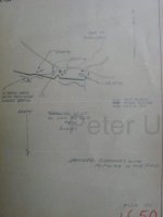


 The other maps had notations about cows setting off the mines and them finding dead cows and detonated mines. Poor hamburgers.